Testing an Inflatable Space Station Module to Destruction

Here is more about Sierra Space’s Large Integrated Flexible Environment (LIFE) habitat.
Testing an Inflatable Space Station Module to Destruction
Here is more about Sierra Space’s Large Integrated Flexible Environment (LIFE) habitat.
Most Americans would envy his life:
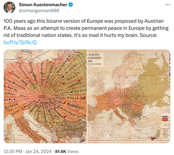
(Click for full map.)
This enigmatic map illustrates a complex utopian scheme for radically-restructured European unification after World War I. It was produced by “P.A.M.,” an elusive figure, to accompany a 24-page pamphlet (“The Central European Union! A Guide to Lasting Peace”) describing his plan in elaborate detail.
⋮
As the map shows, the future United States (“Einheitsstaates”) are composed of 24 “Kantons,” each a long, narrow, pie-shaped slice named after a prominent European city within it, which is to be the capital of the Canton. P.7. The “wedge-shaped division” was adopted “only in order to create the most concessionary and fairest part of the whole territory of Central Europe,” so that traditional disputes among European peoples “were solved and buried forever.” P.10. “The cantonal tips meet in a point at the Union’s capital, St. Stephen’s” Cathedral in Vienna. The inset map at the bottom left suggests that the capital itself ("Unionshauptstadt ") will be called “Saint Stephen,” and is intended to be a large area surrounding metropolitan Vienna (also referred to as the Garden State). The selection of Vienna as the capital is not explained apart from the P.A.M.'s personal view: “This I think of myself as a large, wide garden city, hygienically designed and expanded.” P.10.
⋮
The supporting Guide contains extensive detail on scores of other aspects of the new Union. On colonies, for example, “All colonies of the countries within the Union will be jointly owned. As it is better to have everything connected, area exchanges were necessary,” with eventual financial compensation. (A separate map is of colonies is provided, ID #2104.02, showing that most of Africa has become a Colony Owned by the Union.") Details are provided as to colonies of England, The Netherlands, Italy, Portugal, Spain, etc. Pp.13-14. The President of the Union is to serve a three-year term, and the position is to be rotated among the four Nations. All those over 20 may vote - except for married women. P.14. “Esperanto, the modern world language” should become the common language of the Union. “Immediately after the creation of the Unified State, all teachers must attend courses aimed at the rapid and thorough learning of this universal language. . . . Half of the available teaching time would have to be used for the basic Esperanto study, the other half for the subjects and the mother tongue.” (Religion, on the other hand, “is to be given in the mother tongue for the time being.”) P.4. Other details include the flags of the Union, several of which are shown on the map.
A more recent version of this idea:
Voronoi diagrams FTW!
Google Scholar shows a few recent papers on this topic (source)
Here is one paper (link)
We had a related post here on 2021-12-01, “Apportionment Paradoxes—‘Fairness’ Is Impossible”, which described the problem of deciding how many U.S. house of representatives seats shall be assigned to each state based upon their population as prescribed by the U.S. constitution. As I noted in that post, in 1983 two mathematicians proved a theorem showing that any apportionment system which does not violate the quota rule will, when allocating to three or more states, always manifest one or more of the apportionment paradoxes. The fundamental problem, stated as a programmer would, is that they’re trying to store a rational number into an integer variable, and however you try to do it, you’re always going to lose significance.
The problem of drawing districts is far more complex. If you go through the desiderata for district boundaries given in the Quanta article, it’s immediately apparent they are mutually contradictory in a variety of ways. For example, if you draw districts to try to mirror the racial demographics of the state as a whole, votes of small minorities will be diluted by the majority and never affect the result on issues that matter to them or, in tribal terms, elect members of their group. If you draw the boundaries to create “minority majority” districts so that, assuming tribal voting, the composition of the legislature mirrors the racial composition of the state as a whole, then if the minorities vote heavily for one party, those districts will not be “competitive” and effectively one-party rule, and so on. It gets even worse and more contentious when one tries to determine which minorities are entitled to having districts drawn to grant them representation.
This is a problem which not only suffers from a combinatorial explosion if you try to exhaustively seek an optimal solution, it’s one in which the definition of an optimal solution is impossible to achieve even in principle because the criteria contradict one another and furthermore are written in lawyer-speak and interpreted by judges to mean all kinds of different things, so the problem is ill-defined.
(click through the links to see the photos - it’s just the embeds that don’t work)

Joshua Turner, who made the video, notes:
FPV drone flight up the Matterhorn’s epic Hornli ridge. I’ve wanted to try this flight for a while and finally went for it during my month in Switzerland this winter (2022). I flew an Iflight Chimera 7 with DJI air unit and crossfire. The video was shot on a GoPro Hero 10 in 5K 30 and stabilized in Realsteadygo.
I only brought 1500mah batteries so the only way to assure that I reached the summit was to get closer. I decided to leave my skis at the top of the lift and hike the rest of the way to the Hornli Hut with crampons and ice axe as the path was covered in snow and ice. I launched the drone from the Hornli Hut and I was able to fly the remaining 4000ft (1,200m) vertical and 1 mile (1.6km) distance to the summit and surf down the ridgeline. It was extremely windy and the wind just got stronger as I neared the summit but the chimera 7 performed very well.
Holtzapffel rose engine lathe #1636, geometric chuck:
![H-1636-Geo-Chuck-Front|690x505]
Many other fine pictures of the complete lathe and tools may be seen there.
This 1838 lathe cost 1850 pounds, or about $250,000 in today’s money. The chuck acts like a 3D Spirograph for ornamental turning.
To see what artists can make with such machines:
The spoils of victory on Wall Street
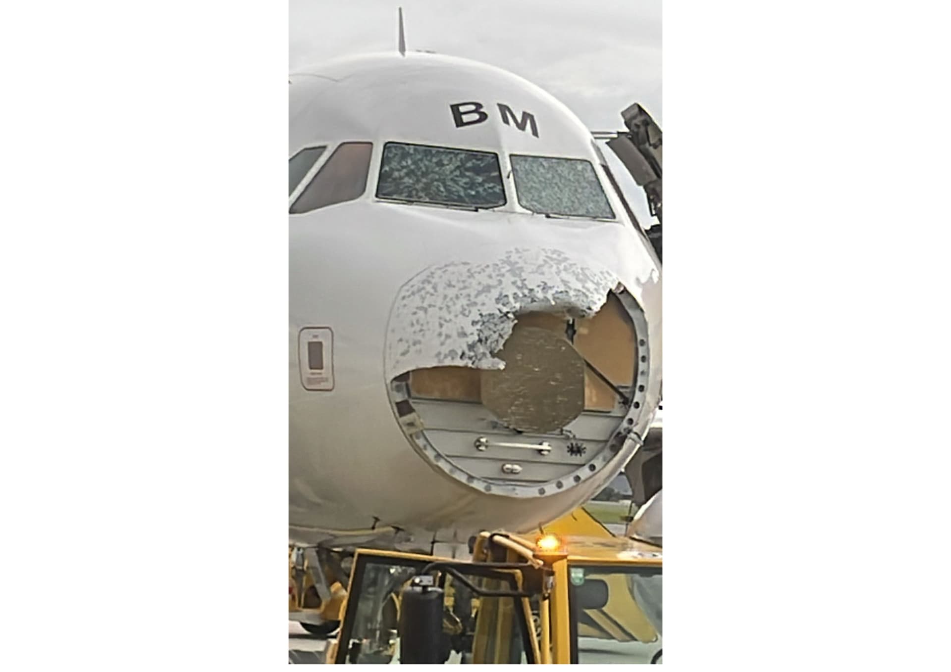
AustrianWings A320 severely damaged by hailstorm in flight:
 John Cena")